Flight time from San Luis Potosí to Nassau
How long is the flight time from San Luis Potosí to Nassau?
The flight time between San Luis Potosí and Nassau is 3 hours 28 minutes.
What is the Flight Distance Between San Luis Potosí and Nassau?
The flight distance from San Luis Potosí (Mexico) to Nassau (The Bahamas) is 1509 miles or 2428 kilometers or 1310 nautical miles.
The calculated distance between two cities is the straight flight distance measured from one point to another by air. The nearest airport to San Luis Potosí is Aeropuerto Internacional Del Bajío (BJX) and the nearest airport to Nassau is Lynden Pindling International Airport (NAS).
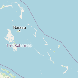
Map of flight path from San Luis Potosí to Nassau
The map of the shortest flight path between San Luis Potosí, Mexico and Nassau, The Bahamas is displayed below.
                   Leaflet | © OpenStreetMap |
San Luis Potosí Details
San Luis Potosí is located in Mexico.
| GPS Coordinates | Latitude: N 22° 8' 59.4'' Longitude: W 100° 58' 45'' |
|---|---|
| Latitude | 22.14982 |
| Longitude | -100.97916 |
| Country | Mexico |
Ponciano Arriaga International Airport (SLP)
Nassau Details
Nassau is located in The Bahamas.
| GPS Coordinates | Latitude: N 25° 4' 0'' Longitude: W 77° 19' 60'' |
|---|---|
| Latitude | 25.066667 |
| Longitude | -77.333333 |
| Country | The Bahamas |
Lynden Pindling International Airport (NAS)
Time Difference between San Luis Potosí and Nassau
Time difference between San Luis Potosí (Mexico) and Nassau (The Bahamas) is 2 Hours.
Nassau time is 2 Hours ahead of San Luis Potosí.
Nassau time is 2 Hours ahead of San Luis Potosí.
| Current local time in San Luis Potosí | Current local time in Nassau |
|---|---|
| 2025-10-08, 22:39:38 CST | 2025-10-09, 00:39:38 EDT |
Popular Searches from San Luis Potosí
Popular Searches from Nassau
Please add a bookmark (press CTRL+D to add) and share the page with your friends!